
Best hikes in Tahiti: hiking trails and tips to discover French Polynesia
Most of Tahiti's population is located along the coast between the towns of Mahina (north) and Punaauia (south). Beyond a few inhabited valleys and mountain sides occupied by residential and commercial zones, the heart and the rest of Tahiti - the largest island in French Polynesia - are very well preserved, perfect for accessible hikes and more sporty trails.
This makes it a true paradise for hikers eager to venture through untouched, lush jungles, accompanied by the songs of exotic birds and the soothing sounds of rivers and waterfalls.

The caldera from the sky: a helicopter ride over Tahiti
To grasp the majesty of this ancient volcano, I must share an unforgettable excursion: a scenic flight with Tahiti Nui Helicopter. We took off from Faa'a and flew over the heart of Tahiti, the caldera and its slopes rising to over 2,000 meters (1,2 miles).
We flew along these cliffs sculpted by time, skimming the grassy peaks with the helicopter's skids, feeling cool breezes from the majestic waterfalls. The tour ended with a graceful descent through the Papeno'o Valley, following the curves of the river. I still dream about it to this day.
Tahiti is a perfect destination to discover nature and its wild beauty. Here are six hikes around the island, starting from Papeete. We'll head to the peninsula before circling back to the east coast.
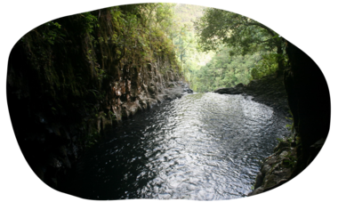
Loti's bath hike in Tahiti – no guide required
In Papeete, the island's capital, a historically rich hike begins in the Fautaua Valley, after the industrial and commercial area of Titioro. There are refreshing waterfalls, the ruins of Fort Fachoda - an ancient fortification built by Tahitian fighters during the 1846 war against the French - and a waterfall with pools called “Bain Loti”, named in honor of Louis Viaud, known as Pierre Loti, who loved this place.
The trail is located on an area owned by the Polynésienne des Eaux company and a small fee is required to hike there: approximately $5 USD per adult and $1.30 USD per child. You can make your reservations at the Papeete City Hall.
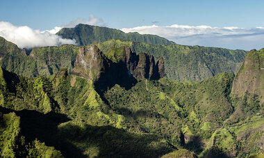
The Valley of the Orange Trees trail – with guide
Climbing Mount Marau via the Miri Valley is one of the most famous hikes in Tahiti (Punaauia) thanks to its stunning views of the lagoon and Moorea. But if you hike a lot, I recommend the Tamanu Plateau, the ultimate hike for experienced walkers.
To reach the plateau of orange trees, a fee of 1,000 CFP per hiker is required (maximum of 12 hikers per group). This fund supports the Punaruu Valley Protection Association which preserves the area and its iconic orange trees.
This trail is not open all year round and usually takes around seven hours to complete. Good weather conditions, good physical condition and a solid level of fitness are essential, especially for the climbs and sections requiring ropes. At the end of the journey, hikers are rewarded with natural cool water pools and, of course, a taste of the fresh oranges!
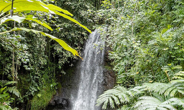
The Vaipahi Water Gardens hike – no guide required
Head to PK 49 (49-kilometer mark) of Tahiti to admire these gorgeous gardens inaugurated in 2007. The Water Gardens of Tahiti are truly beautiful, featuring aquatic plants, historical ruins, and ancient legends. This is also the starting point for a 3- or 5-kilometer (1,8 - 3 miles) loop hike.
This trail is ideal for families, although the first few feet after the waterfall are a bit challenging. The peaceful walk through the pine forest, the picnic areas, and the view of the lagoon and the gentle curves of Tahiti’s peninsula (presqu'île) are the highlights of this amazing day of discovery.

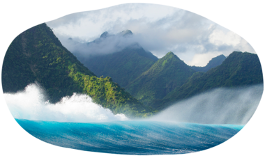
Te Pari & Fenua aihere hikes - with guide
Explore Tahiti’s wild east coast in Tautira, known as fenua aihere, or discover the eastern cliffs just past Teahupo'o, called Te Pari. These two hikes are located at the far southern tip of the peninsula, surrounded only by the ocean as far as the eye can see.
They offer a rare combination of beautiful landscapes, lagoons, beaches, rivers, reef flats, and giant trees with roots shaped like cathedral columns.
These two unspoilt places can only be reached by boat. They tell the story of the Tahiti of yesteryear, a place barely touched by human presence except for sacred rock carvings left as tributes to ancient gods. It's more than a hike, it’s a unique journey and, as you navigate the few obstacles along the hike, it's also a lot of fun!
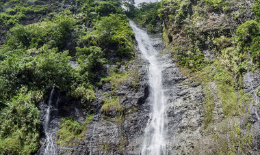
The three waterfalls of Tahiti – no guide required
Skip the air conditioning and lower your car windows to feel the tropical air as you head to Tiarei in the Fa'arumai Valley. After applying some mosquito repellent, set off on this bucolic walk, a perfect waterfall hike in Tahiti. In just 30 minutes, it will take you to three waterfalls cascading over the eroded basalt cliffs. You will feel a sense of well-being in this place: according to the legend, love created these waterfalls.
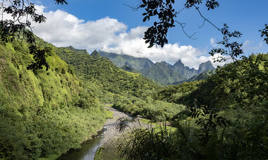
The Papeno'o valley hike – with or without a guide
Papeno'o, the great valley of northern Tahiti, was an important place in ancient Polynesian times. Here, you will find important archaeological remains and Tahiti's largest hydroelectric dam. Further inland, a track leads to the Maroto relay station, the only hotel within the caldera, offering a complete change of scenery, surrounded by mountains. This hike is one of the best things to do in Tahiti.
In Reo Ma'ohi (tahitian language), words carry a deep meaning. The river that flows through the Papeno'o Valley is the largest in Tahiti. It is called Vaitū'oru, which can be translated as “rising like a violent wave.” Indeed, rainfall on the north coast can be heavy, and Vaitū'oru is quickly fed by a network of springs, waterfalls, and rainwater runoff from the peaks, causing it to swell rapidly and violently.
Always check the weather forecast and find information before hiking here.
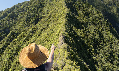
The high mountains and the Belvédère road
Just before heading back, let me invite you on one last excursion: a mountain trip. From the traffic circle surrounding the impressive colonnaded city hall in Pirae, take the road to the Hamuta Valley (mountain side).
At the end of this road lies a magnificent trail (entrance fee applies, as it's on private property) leading to the former domain of the legendary warrior Tahiri, with her marae, cave, and freshwater pool. However, this time, I suggest taking the first road on the right into the valley, known as the Belvédère Road. After a few miles, you will reach the parking lot of a mountain restaurant, the starting point of the Mount Aorai hike. Mont Aorai is one of Tahiti's most famous peaks, like Mont Otemanu in Bora Bora. You can choose to do just the initial hike or continue with the more challenging ridge trail (reserved for athletic hikers who are not afraid of heights).
As a reward for your walk, stay for lunch or dinner at the restaurant. Among other things, you can enjoy an unusual dish in Tahiti thanks to the cooler temperatures at this altitude: a Savoyard fondue!
Our tips for hiking in Tahiti
When meeting locals, always be respectful and grateful. The land ownership system in Tahiti is relatively complex, and many trails pass through privately-owned lands. Often, these generous landowners grant access freely.
Please respect the area, follow the signs, and do not pick or disturb anything. And of course, take all your trash with you, including any litter you may find along the way.
Important: always check the weather conditions for the day of your hike, as well as conditions for the days prior. Rivers rise quickly on the basalt soil, which runs off easily when it rains. The paths can become slippery. Don’t be caught off guard—inform your hosts of your plans, carry proper gear, and ensure your phone is charged and traceable.